Norr Döttern Uranium and REE Project
Overview
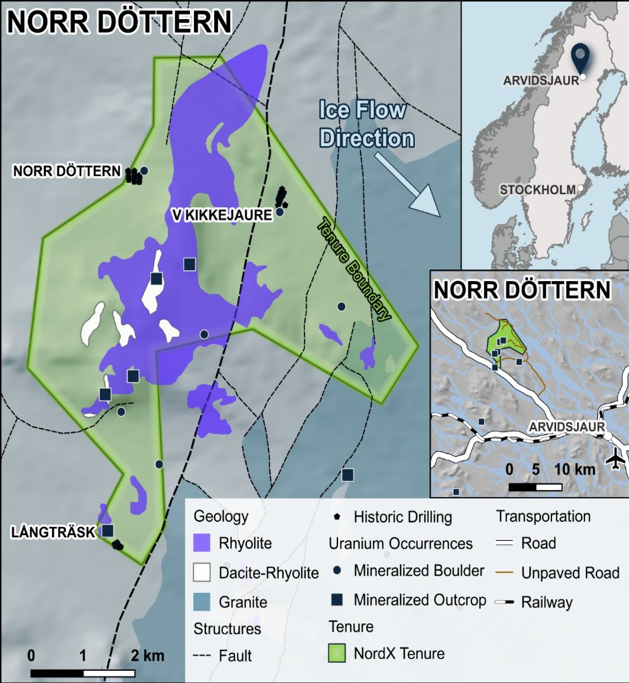
A >8-kilometre structural uranium corridor (SGAB, irap-85048) in northern Sweden with outcropping mineralisation, drilled across three state-program campaigns (~4,900 m within NordX Metals´ Norr Döttern tenement), and historically modelled open in all directions (SGAB, IRAP-85026). Two mineralisation styles (structurally-controlled uraninite veins and granite-related / episyenite uranium), Up to 28% U₃O₈ in a historic channel sample on the ND2 fracture zone (SGU Uranium report 1983-4)¹, and several mineralised boulder trains along the same NE–SW trend.
At a Glance
Location
Berget Norr-Döttern, near Arvidsjaur, Norrbotten County (Lapland), northern Sweden — the Arjeplog–Arvidsjaur–Sorsele uranium province
Tenure
Exploration permit “Norr Döttern nr 101” (2023:88), 2,900 ha — granted; extension granted
Ownership
100%, via Swedish Minerals AB
Commodity
Uranium (± rare earths)
Setting
A >8 km NE–SW structural corridor, with dilation zones and structural complexity
Deposit Style
Two styles — structurally-controlled uraninite veins + granite-related (episyenite / Na-metasomatic) uranium
Prior Operator
Sweden’s state uranium program (SGU/SGAB), 1971–1985
Stage
Historically drilled — ~35 core holes / ~4,900 m inside the permit across three campaigns (1974–75, 1977–78, 1983–84); historical non-compliant estimates.
Why It Matters
Diamond drill intercepts up to 11.9 m @ 0.1% U₃O₈. Sweden’s state program shelved it on policy in the mid-1980s and no one has re-tested it since — so NordX inherits substantial prior work and multiple drill-ready targets along the corridor.
Geology & the Target
Norr Döttern sits in the Arjeplog–Arvidsjaur–Sorsele uranium province — Svecofennian (~1.75 Ga) felsic volcanics and granite. Mineralisation runs along a >8-kilometre NE–SW structural corridor with abundant dilation zones and structural complexity — the kind of setting that focuses uranium-bearing fluids. Two styles occur together: structurally-controlled uraninite veins, and granite-related (episyenite / sodium-metasomatic) uranium.
Historical Results
Historical, non-compliant figures — disclosed by the state program / prior work, not independently verified, and not a current mineral resource.
- High-grade channel samples — the ND2 uraninite fracture zone (discovered 1974) returned a channel sample up to 28.2% U₃O₈ over 0.2 m, within a ~3 m interval at 3.5% U₃O₈.
- Historic drilling —From 1974–75, a ~2,493 m campaign (12 holes) defined a mineralised lens at the Västra Kikkejaure prospect. From 1977–78, the Norr Döttern 1 prospect was drill-tested over 1,635 m with grades up to 0.33% U₃O₈ , best intercept was 5 m @ 0.15% U₃O₈ from 55–60 m (4 of 12 holes mineralised). From 1983–84, just a year before Sweden’s state uranium program was officially ceased, the Långträsk occurrence was drill-tested over ~1,270 m with a best assay result of 11.9 m @ 0.1% U₃O₈ from 18.6m downhole. Other significant assays from Långtrask included 6.4 m @ 0.1% U₃O₈ from 77m downhole, 6.2 m @ 0.088% U₃O₈ from 82.3m downhole and a higher-grade zone of 1.6 m @ 0.17% U₃O₈ from 41.7m downhole.
- District-scale boulders — at least 1,976 mineralised boulders at 0.06–1.53% U, across several trains 50–1,500 m long and 100–250 m wide on the same NE–SW trend; not all have been assayed (float, not bedrock).
- Rare-earth credits (documented in an SGU survey) — a 1977 Geological Survey of Sweden compilation registered 142 uranium-mineralised blocks carrying ≥200 ppm yttrium and/or ≥500 ppm zirconium across the district (all figures historical; blocks are float, not bedrock).
Basis note: All figures are historical and non-compliant, not independently verified, and not current resources. Uranium appears on different bases per source — % U₃O₈, % U, and radiometric dose-rate (µR/h) — kept strictly separate and never merged; a dose-rate reading is not a grade. Yttrium and zirconium are reported separately again (% Y, % Zr). Surface channel/outcrop and boulder/grab samples are not bedrock grades and are not representative of the deposit as a whole.
Exploration History
- 1971–1985 — Geological Survey of Sweden (SGU/SGAB): the state uranium program — boulder tracing, regional and detailed geology and geophysics (ground magnetics, Slingram, VLF), regional and detailed geochemistry, stream sampling, radon surveys, Quaternary studies, trenching, three core-drilling campaigns and a first resource estimate.
- 2005–2011 — Geoforum Scandinavia AB: geochemistry and scintillometer surveys.
- 2006–2014 — Hodges Resources Ltd: ground magnetics and scintillometer surveys.
- 2006–2015 — Swedish Geological Survey: regional LiDAR.
Norr Döttern comes with a favourable social-licence signal. In regional planning to identify areas for wind-power development, the area has been highlighted by the region and the local municipality as suited to development — a positive read on the environmental and community setting, and a contrast with more contested mining districts. NordX’s current activity is exploration-stage.
Important Considerations
- Historical, non-compliant — the estimate and grades predate and do not comply with current standards; they are not independently verified and are not current resources.
- Surface and float samples — the 28% U₃O₈ is a narrow surface channel sample; the boulder/block grades (including the yttrium–zirconium figures) are float, not bedrock; neither is representative of the deposit.
- “Open in all directions” is a historical model — an interpretation from 1970s work, not a modern resource.
- Early-stage — value depends on modern drilling; historical results are not a guarantee of future results.
- Historical assay data not independently verified by a qualified person
Social Licence & Setting