
Märrviken Uranium Project
Overview
A 2-kilometre uranium boulder train with high-grade surface samples — in central Sweden.
At a Glance
Location
Near Ånge, central Sweden
Tenure
~2,710 ha
Ownership
100%, via Swedish Minerals AB
Commodities
Uranium (with polymetallic Au-Ag-Cu-Zn-Pb at Storkullen)
Setting
On the deep-seated Storsjön–Edsbyn Deformation Zone — a large brittle-ductile shear zone at the western edge of the Bergslagen litho-tectonic unit
Stage
Boulder train + historic drilling (11 diamond holes 1979–80 + a 1983 campaign; ~31 SGU holes / ~3,542 m in the national DB; no resource
Access
Road and power; railway ~11 km, regional airport ~94 km
Why It Matters
A 2-kilometre uranium boulder train with high-grade surface samples, plus a polymetallic gold–silver–copper sulphide showing at Storkullen — a large, still-untraced mineralised system that limited historic drilling only began to test.
Geology & the Target
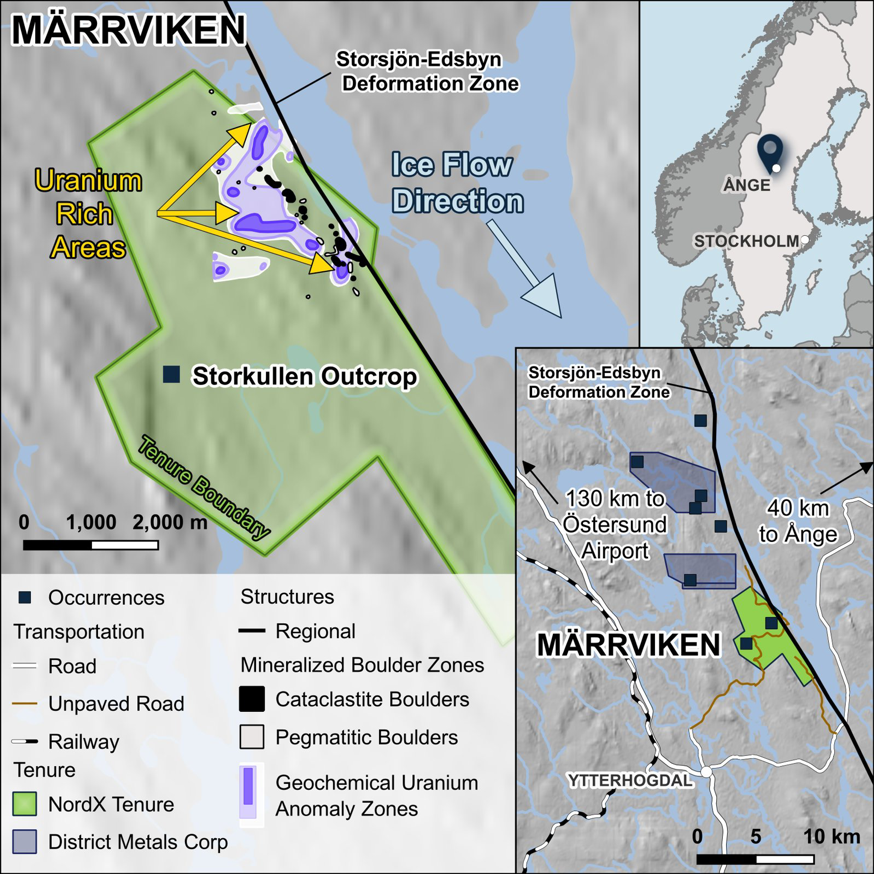
Märrviken sits on the Storsjön–Edsbyn Deformation Zone (SEDZ) — a large, deep-seated shear zone at the western margin of the classic Bergslagen litho-tectonic unit, broadly along the boundary between the ~1.7 Ga Rätan Batholith to the west and older Svecofennian/Svecokarelian rocks (~1.8–1.9 Ga) to the east. It is a complex brittle-ductile structure — dominantly strike-slip, with both western- and eastern-side-up/reverse movement, Riedel structures, cross-cutting faults and several documented reactivation events — the kind of long-lived architecture that repeatedly focuses mineralising fluids (Högdahl et al. 2004; S. Bergman et al. 2006). The uranium is structurally-controlled, with hydrothermal alteration and weathered sedimentary basement rock; the best boulders are cataclasite and brecciated mylonite carrying fine-grained botryoidal uraninite through the matrix.
Project Highlights
- A 2,000 m × 400 m uranium boulder train — 766 mineralised boulders logged by the Swedish Geological Survey, with highlights of 24.7%, 20.37% and 6.01% U₃O₈.
- Shallow uranium in limited historic drilling — 2 m at 0.034% U₃O₈ from 30 m (within an 11 m low-grade halo) and 3 m at 0.029% U₃O₈ from 46 m.
- Polymetallic upside at Storkullen — a 5 m × 3 m massive-sulphide outcrop with a grab sample of 23.3 g/t Au, 77.2 g/t Ag, 0.94% Cu, 0.33% Zn, 0.21% Pb.
Basis note: All figures are historical and non-compliant, not independently verified, and not current resources. Boulder and grab samples are not bedrock grades.
Historical Results — in Detail
Historical, non-compliant figures — disclosed by prior operators or the state program, not independently verified, and not a mineral resource. Boulder, outcrop-grab and trench samples are selective surface samples, not bedrock grades; drill and trench widths are downhole/down-dip, not true thicknesses.
- Uranium — boulder train. A 2,000 m × 400 m train of 766 mineralised boulders logged by the Swedish Geological Survey; the best are cataclastic with botryoidal uraninite. Reported maxima are 24.7% / 20.37% / 6.01% U₃O₈.
- Uranium — drilling. ~31 holes named Märrviken for ~3,542 m — the 11 diamond holes of 1979–80 plus a shallower 1983 campaign of ~20 holes. The deeper program was cut short when the state uranium program ended.
- Polymetallic sulphides — Storkullen. A ≥5 m × 3 m massive-sulphide outcrop with bornite and high gold; three separate grab samples returned: – 23.3 g/t Au, 77.2 g/t Ag, 0.94% Cu, 0.33% Zn, 0.21% Pb – 33.8% Zn, 11.6 g/t Ag, 0.49% Pb (with 0.05 g/t Au, 10 ppm U) – 4.35 g/t Au, 35.8 g/t Ag, 6.6% Zn, 0.57% Cu, 0.1% Pb.
- Associated drill hits include 0.45 m @ >30% Zn, 18 g/t Ag, 0.07 g/t Au (from 35 m down-dip) and 0.23 m @ 25.8% Zn, 35 g/t Ag, 0.08 g/t Au (from 50 m down-dip). Shallow trenching over the sulphide horizon returned high-grade zinc–lead–silver over narrow widths — to >30% Zn, with 1.3% Pb and ~46 g/t Ag. (Full trench tables are in the company deck.)
Basis note: All figures are historical and non-compliant, not independently verified, and not current resources. Uranium appears on both % U₃O₈ and % U / ppm U bases per source — kept separate, never merged. Surface, boulder and grab samples are selective and not bedrock grades; drill/trench widths are not true thicknesses.
Exploration History
- 1976–1989 — Geological Survey of Sweden (SGU): the original state uranium/base-metal program — boulder tracing, regional and detailed geology, geophysics (ground magnetics, Slingram, gamma), geochemistry, Quaternary studies, radon surveys, and diamond and cobra drilling.
- 1998–2003 — Tertiary Gold Ltd: regional gold prospecting.
- 2005–2011 — T.A. Metall Sweden AB: geochemistry and scintillometer surveys.
- 2008–2009 — Hans A. Resources Sweden AB: ground geophysics, geochemistry, trenching and diamond drilling.
- 2008–2016 — Wäsa Stone & Mining AB: detailed boulder tracing and diamond drilling.
- 2018–2021 — Erris Resources: limited work.
- 2006–2015 — Swedish Geological Survey: regional LiDAR.
- Historical assay data not independently verified by a qualified person