
Flistjärn Uranium Project
Overview
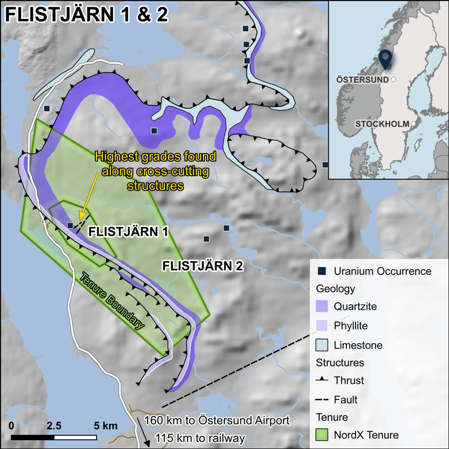
A 20-kilometre uranium corridor in the Olden tectonic window of central Sweden with surface rock-chip assays to 21.06% U₃O₈ in structurally-controlled veins. The area has never been drilled.
At a Glance
Location
Olden window (Oldenfönstret), Åre kommun, Jämtland, central Sweden — Caledonides, near the Norwegian border
Tenure
Two granted exploration permits — “Flistjärn” (2023:18, ~745 ha) + “Flistjärn nr 4” (2023:45, ~6,807 ha); ~7,552 ha combined; valid until 2029
Ownership
100%, via Swedish Minerals AB
Commodity
Uranium (with silver)
Setting
A structural corridor with NE-trending mineralised cross-cutting structures
Deposit Style
Granite-related vein / joint-filling uranium (colloform pitchblende; IAEA Type 2), structurally controlled, polymetallic (U-Pb-Cu-Ag-Bi)
Prior Operators
Swedish state program (SGU/SKBF, 1976–1985); Mawson Resources / Energi (2005–2011)
Stage
Surface exploration only.
Geology & the Target
Flistjärn lies in a structural window in the central Swedish Caledonides where a fertile ~1.65-billion-year-old granite is re-exposed beneath thin Caledonian cover. The uranium is structurally-controlled, fracture-hosted colloform pitchblende along NE-trending cross-structures — it cuts discordantly across the rocks rather than lying along a bedding plane or an unconformity, so the high grades are governed by structure, not stratigraphy. The system is polymetallic (uranium with lead, copper, silver and bismuth, plus an arsenic pathfinder) and is traceable over ~20 km. The genetic model is straightforward: uranium was leached from the fertile granite by later (Caledonian) fluids and re-precipitated at structural redox traps (against pyrite and iron in the wall rock).
Historical Results (surface only — never drilled)
Historical, non-compliant figures — surface rock-chip and boulder samples, selective and not representative of any volume; the property has never been drilled.
- Fracture-zone rock chips (10 samples): 0.07–21.06% U₃O₈.
- Surface samples (600 × 550 m area, 10 samples): averaging 5.45% U₃O₈.
- Surface samples (450 × 600 m area, 36 samples): 0.01–19.1% U₃O₈ (average 1.7%).
- Radon-cup survey over a 500 × 100 m area of the high-grade rock-chip sampling (surface radon method — a targeting tool, not a grade).
Basis note: All figures are historical and non-compliant, not independently verified, and not a mineral resource. They are surface rock-chip and boulder samples — selective, not representative of a volume, and not bedrock grades. No drilling has been done on the property.
Important Considerations
- Selective sampling — high-grade surface chips are chosen samples and are not representative of the deposit; averages over sampled areas are not resource grades.
- Early-stage — value depends on a first drill program; surface results are not a guarantee of what drilling will find.