
Riutta Uranium Project
Overview
Five uranium bodies on one permit — open at depth and along strike. Finland’s only past-producing uranium mine (Paukkajanvaara) and a drilled, high-grade structure (a historical intercept up to 9.79% U₃O₈), on former AREVA (now Orano) ground.
At a Glance
Location
Kontiolahti / Joensuu (former Eno), North Karelia, eastern Finland; Koli–Kaltimo belt; ~30 km north of Joensuu
NordX Tenure
Exploration permit ML2025:0023 “Riutta”, ~945 ha, 100% owned via Swedish Minerals AB.
Prior Operator
AREVA (now Orano) explored the ground in the last uranium cycle
Commodities
Uranium (± vanadium) · copper–gold–silver · kyanite–andalusite (± molybdenum)
Stage
Drill-ready targets defined at Riutta South
Jurisdiction
Finland — a tier-1 European mining jurisdiction (Finnish Mining Act)
Access
Road and power infrastructure; regional highway, rail and services at Joensuu (~30 km)
The Opportunity
NordX’s ~945-hectare Riutta permit is a compact permit that consolidates the belt’s documented mineralisation onto one holding: Finland’s only past-producing uranium mine, a drilled high-grade structure, and three district occurrences, open at depth and along strike with a historic kyanite–andalusite deposit and a historic copper–gold mine also within the Riutta tenement.
Project Highlights
- Finland’s only past-producing uranium mine on the permit — Paukkajanvaara (test-mined 1958–1961).
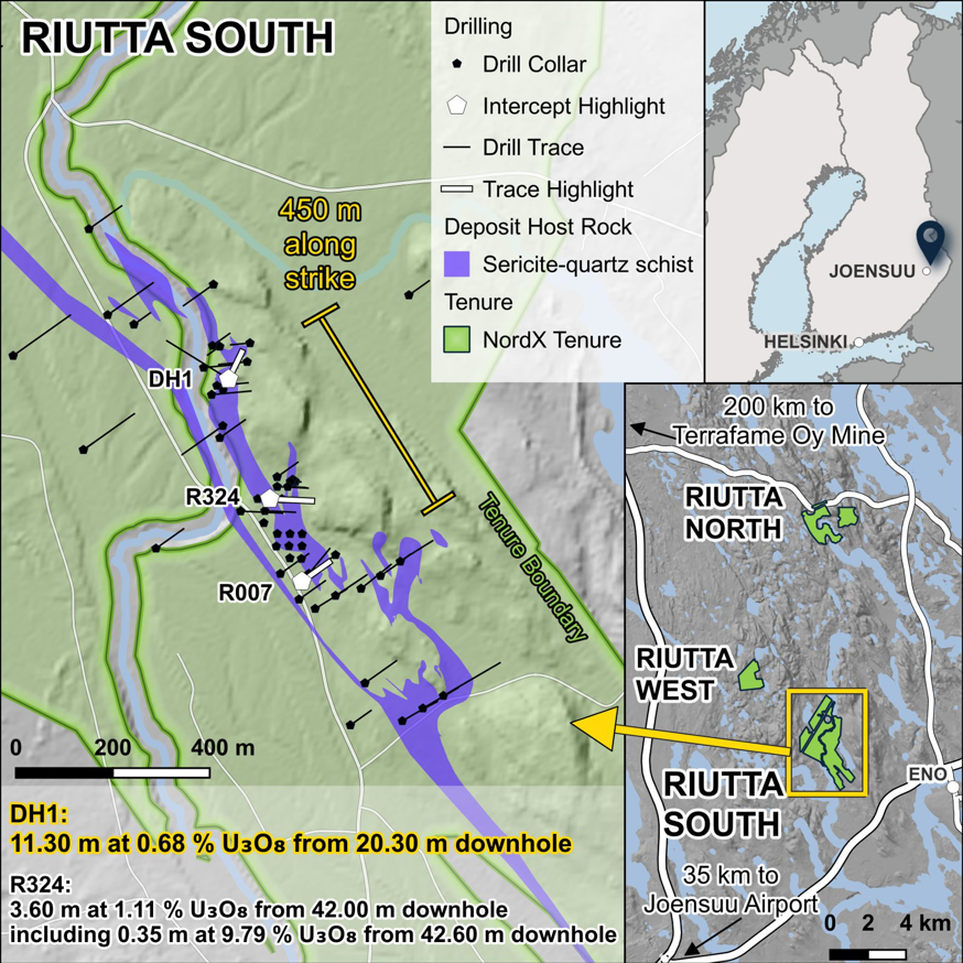
- High-grade uranium, drilled and shallow — a historical intercept of 11.3 m at 0.68% U₃O₈ from 20.3 m downhole, plus a separate high-grade zone grading 3.6 m at 1.10% U₃O₈, including 0.35 m at 9.79% U₃O₈ — two separate high-grade zones intersected in drilling along the mineralised structure (Mawson Resources’ 2011 U₃O₈ restatement of AREVA- and GTK-era drilling).
- Extensively drilled historically — roughly 65 holes for ~6,275 m across the Riutta uranium ground.
- Drill-ready — targets defined at Riutta South.
- AREVA drilling cut short —AREVA’s 2008 program (10 holes, ~1,061 m) was abandoned mid-campaign and switched to a closing study and the core was never chemically assayed at the time — only radiometric logging.
- Exceptional infrastructure — road- and power-served, on low-relief ground ~30 km from Joensuu, with regional highway, rail and full services within easy reach.
Basis note: Every grade and intersection here is historical and non-compliant — disclosed by prior operators or geological surveys, not independently verified by NordX, and not classified under NI 43-101, JORC or PERC. No current mineral resource or reserve exists. Uranium figures are on the U₃O₈ basis (Mawson 2011 restatement); AREVA’s 2008 holes were logged radiometrically, not chemically assayed.
Other Commodities
Historical, non-compliant, not independently verified — exploration context, not current resources.
Copper–gold–silver
- A historic copper–gold mine (Hokka) and a drilled copper–gold–silver target: best historical drill sample 0.8 m at 2.8% Cu, 2.99 g/t Au and 18.6 g/t Ag (Hokka); boulder grab samples up to 32.4% Cu, 6.4 g/t Au and 197 g/t Ag (maxima from separate grab samples; boulder grab, not bedrock).
Kyanite–andalusite (industrial minerals)
- A historic kyanite mine on the core, and a historical aluminosilicate resource on the order of 25 million tonnes at about 13% (kyanite + andalusite), trial-mined (20,000 t) by Keramia Oy in 2000.
Geology & Setting
Riutta sits on the Koli–Kaltimo belt, a Palaeoproterozoic (Karelian) sequence on Archaean basement. Two features control the mineralisation and run the length of the permit corridor:
- The Hokkalampi palaeosol — a metamorphosed deep-weathering horizon that hosts the kyanite–andalusite and forms the surface against which the structurally-controlled uranium sits.
- The Koli quartzite and diabase corridor — host to the vein- and conglomerate-style uranium and to the copper veins.
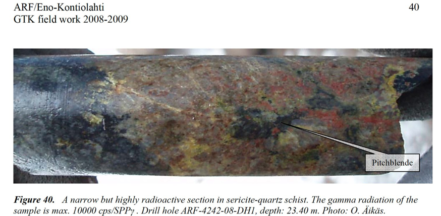
The documented uranium is pitchblende in fracture and fault zones — a structurally and stratigraphically controlled system, with high-grade zones intersected at shallow depth. Riutta is the most strongly faulted ground in the Koli–Kaltimo area, where Archaean basement is thrust against the Proterozoic cover.
In more detail, the bedrock is Archaean ortho- and paragneiss overlain by Palaeoproterozoic quartzitic metasediments (the Jatulian Herajärvi Group), with a unit of sub-Jatulian palaeoregolith between the quartzites and their Archaean basement; three mafic dyke suites cut the sequence (the ~2.2 Ga layered “karjalite” sills, the ~2.1 Ga Fe-tholeiitic diabases and the ~1.97 Ga tholeiitic diabases). Mineralisation sits in steep brittle-ductile fault networks with a reverse sense of movement meeting gently-dipping fault zones; the highest radioactivity (over 50,000 cps on handheld instruments — a field reading, not a grade) clusters around fracture zones, many bearing slickensides that record movement, and thick pitchblende veins cross-cut earlier pitchblende-bearing quartz–carbonate veins. Alteration is multi-stage and extensive — epidote, chlorite, quartz, sericite, albite, K-feldspar, carbonate and clinozoisite, with remobilised sulphides and uranium.
Exploration History
- 1958–1960 — Atomienergia Oy: boulder tracing, radon and radiometric surveys, detailed geophysics, excavation, trenching and core drilling; the Paukkajanvaara mine was test-mined in this period.
- 1961–1968 — Outokumpu Oy: boulder tracing, airborne electromagnetics, gravity, magnetic and seismic surveys, geological mapping and core drilling.
- 1983–1988 — Geological Survey of Finland (GTK): regional and detailed geochemistry and geophysics, radiometric and radon surveys, detailed mapping, trenching and core drilling
- AREVA (now Orano): regional and detailed geophysics and geochemistry, boulder tracing, airborne survey, trenching and diamond drilling — a campaign that ended abruptly on a corporate policy change and was left unfinished (core logging, chemical analyses and other sampling were never completed).
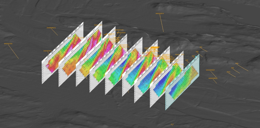
- 2010–2012 — Mawson Resources Ltd: a ~4.5-line-km induced-polarisation (IP) geophysical survey.
- 2022–2023 — Mineral Exploration Network (Suomi) Oy: reservation notification.
Exploration Upside
- AREVA’s unfinished program — cut short mid-campaign, leaving logging, assays and sampling undone: documented targets that were never drilled out.
- A ~700 m radon anomaly on the extension of the Paukkajanvaara mine trend — untested.
- GTK-recommended step-out to the west of the Riutta discovery that was never followed up.
- Expansion along the structural network, where historical cross-sections show large reverse-fault offsets.
Important Considerations
- All figures are historical and non-compliant. No NI 43-101 / JORC / PERC resource exists on the property, and nothing here has been independently verified by NordX. Historical results are not a guarantee of future results.